I'm Steve, and this blog is about what I'm working on or thinking about right now. At least it was when I wrote it. I'm guessing I've already moved on to something else. ;)
Austin Aerials from 1940 in Property Profile. The path of the old Jollyville Road is shown from MoPac to Spicewood Springs / McNeil Rd.
I’d previously mentioned finding online sets of historic aerial photographs of Austin, Texas and it’s surrounds. Those were found by following the link at the bottom of the Austin History Center‘s page for Aerial Photographs. Here is the direct link to that box repository.
Yesterday, I found out that the City of Austin has provided access to some of the the photo sets in a more user friendly format. They’re provided in a map form like you’d find in the satellite view of Google Maps. Wow!
In the upper left corner of the map, click that button that looks like a less than sign to hide the Welcome pane.
Start with the full map, or navigate to your point of interest.
Click the button in the lower left corner (labeled GreyScale…), and then click the All Aerials button when it pops open.
On the basemap slider that pops up, move the time slider to the left.
Imagine a time machine noise as the map loads.
If your map goes/stays blank, your time machine landed off the map. There probably isn’t any aerial data for that year. Zoom out to see where the year’s data is.
If you want to fade the street labels layer into the aerial photo:
Click the Change visible map layers button at the top of the page.
Click the Aerial Street Labels checkbox near the bottom of the list
Vary the slider to the right of the checkbox
You can also add other layers like the red centerlines of today’s streets as shown above.
Click the Change visible map layers button
In the left pane click the checkbox under Property/Address Information/Streets
The street centerlines only show up at higher zoom levels
What did you find?
I absolutely can not wait to find out what others discover or would like to share about Austin’s past. Do feel free to share something here. Also, consider sharing it in your own blog post or in this great Facebook group.
Today Marks 69 Years Since The Opening Of The Lone Star Trail
4/23/2019
I’ve been researching the trail (off and on) since 2003 when I stumbled across a mysterious metal marker in Austin’s Emma Long Park.
Trail? There wasn’t a trail there as far as I could tell. I had no idea how old the marker was. The marker was just nailed to a tree, way back in the woods. The ground around it was undisturbed, maybe for a decade according to my first underestimate. Yes, this plaque turned out to be older than I imagined.
As I found it 11/14/2003
In 2003 I just took a picture and moved on. I was hunting something else, a geocache that promised to be somewhere nearby. I set the mystery aside for a while. I posted a photo of the marker with a question about its unknown (to me) history to the internet in 2005. I got the break I needed in 2012 when someone finally associated it with the old Camp Tom Wooten.
Just a quick note: The trail is not to be confused the Lone Star Hiking Trail that winds through the Sam Houston National Forest. This trail is older, and was opened April 23rd, 1950.
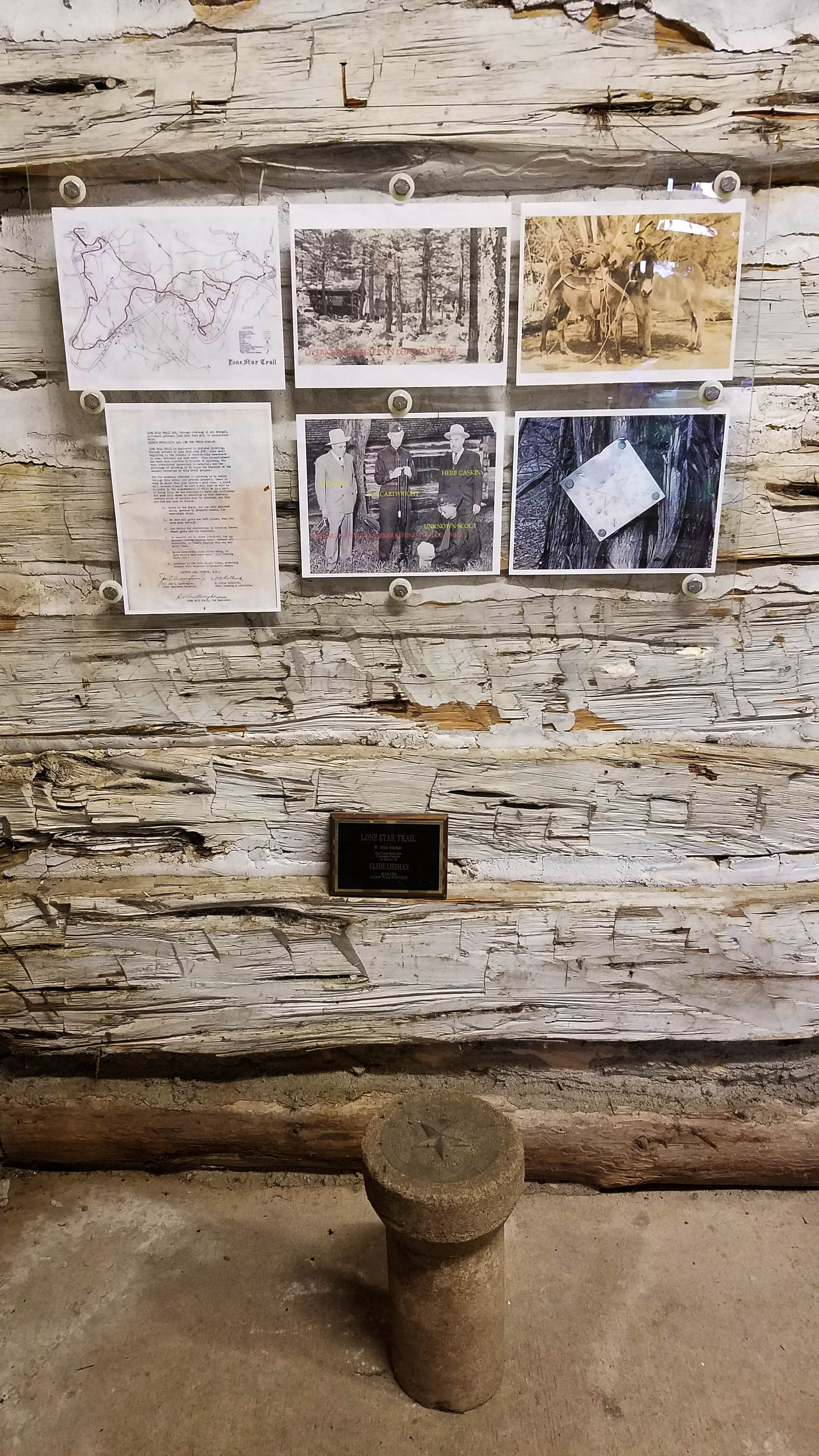
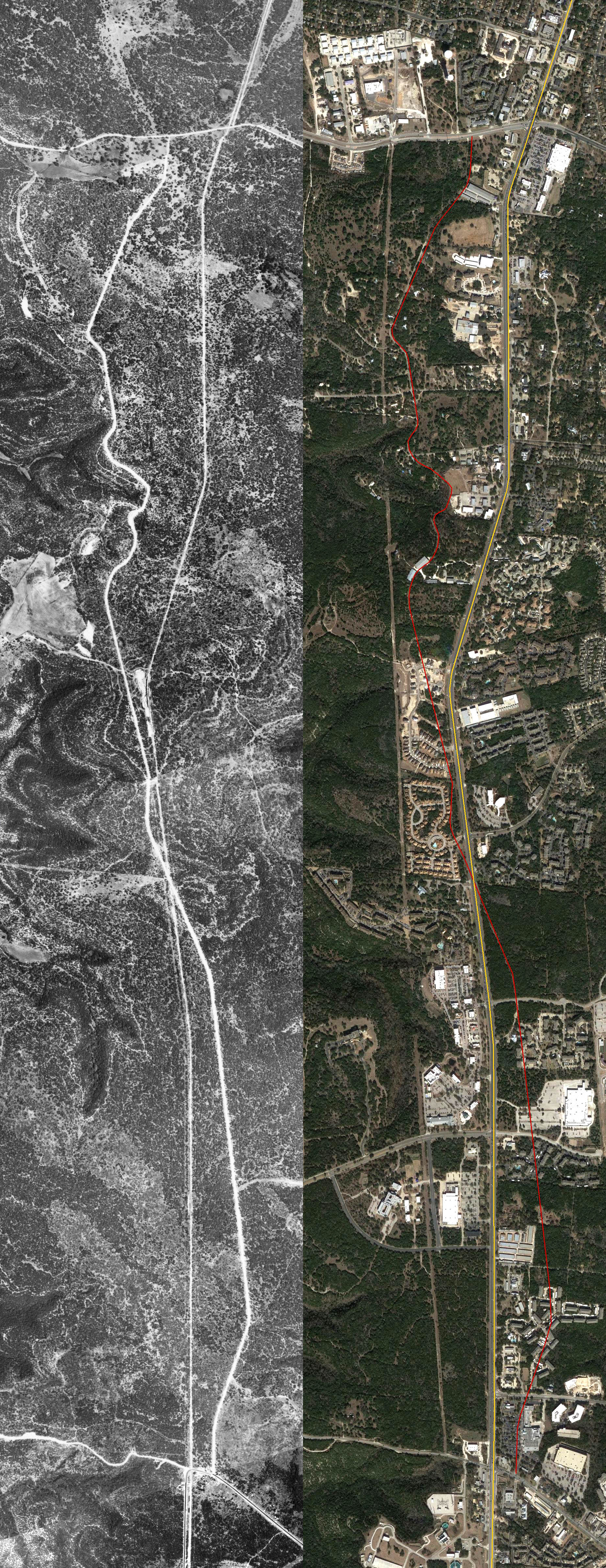
Camp Tom Wooten was the big Boy Scout camp near Austin, operating from about 1937-1972. It was out where The Courtyard neighborhood is near the Pennybacker bridge. Eventually, I found Frank Hilton’s Lone Star Trail website, and the hand drawn map shown above. Wow, a real treasure map! Frank’s site is loaded with information. I greatly appreciate his efforts to keep and distribute the history. Since then, I’ve been looking into where the trail went. From the map, I found out that trail winds through the area where we live in Steiner Ranch, and through City Park / Emma Long Park where I found the marker. I’d already been to many of the places it passes through.
Recently, I’ve been using old City of Austin aerial photographs as overlays in the free Google Earth Pro desktop program to find the latitude and longitude of various places and trails I can see in those aerials. When I take the old overlays off, I can see the locations on a modern satellite image. Most of the trail is invisible from the air in 2019. I can see quite a bit in the 1966 aerials. There were less trees then. To date, I have not yet found any of these concrete milestone markers beyond the one for the start that has been moved to the museum (see below). I suspect they were all gathered up when the trail closed.
I’ve also contributed some to Frank’s web page. Namely the modern map (still incomplete) at the bottom of the page and the photo of the aluminum marker.
The trail started at Camp Tom Wooten (now closed and re-developed) and Frank’s website has some pictures of some spots along the trail. I have actually visited the cave shown in those pictures while geocaching.
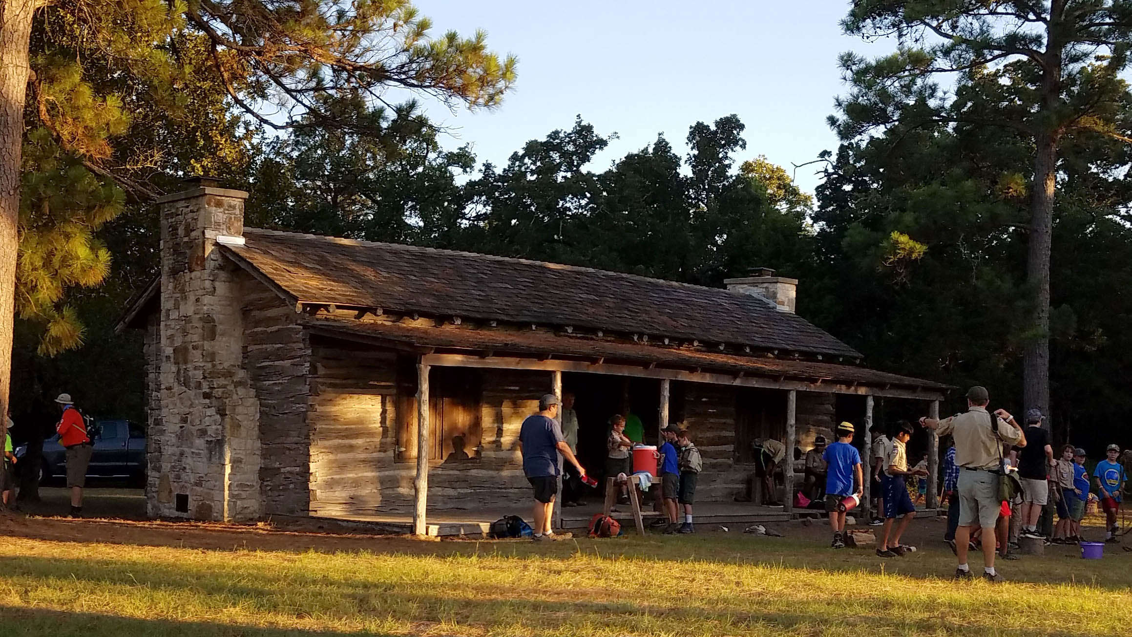
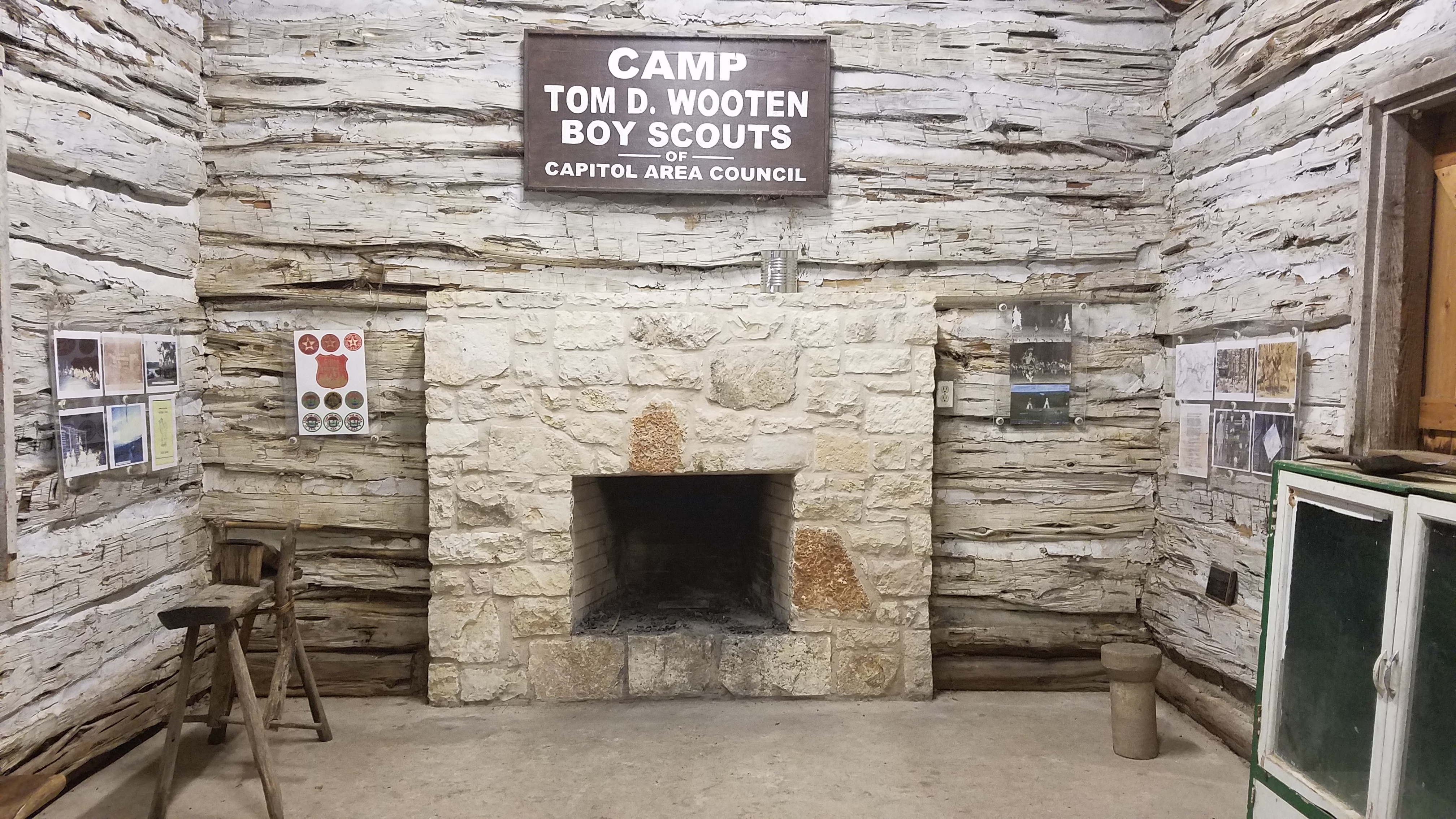
Original Camp Tom Wooten administration/headquarters building (now at Lost Pines Scout Reservation) Camp Tom Wooten museum in the Log Cabin at at Lost Pines. LST exhibit inside the Camp Tom Wooten museum at Lost Pines
In 2018, I retrieved the metal trail marker I’d located and turned it over to the museum. By then, it had fallen neatly from the tree and was ready to go.
I’m now using a much more powerful mapping program called ArcGIS Desktop, and am learning that to finish up a nice printable map.
2/27/2021 update
Another Lone Star Trail Marker, as found 6/1/2020
My son and I like exploring the trail area above the cliff near the camping area in Emma Long Park. We were out there last June and were having a hard time finding a geocache container that had been innocently moved from its original location. As we wandered around and around looking everywhere, my son shouted out: “Dad, I think I found another marker!” Sure enough, he had. In fact we’ve probably walked right past this one every time we’ve been out there. This marker does not have the extra arrows found on the first marker. I presume those were there to mark a turn on the trail. It also has a bunch of .22 bullet holes in it as well as some kind of yellow paint or sticker that has peeled off over the ages.
Sources
Starr, Te (2012). Making a Difference Every Day – 100 Years of Central Texas Scouting – The History of the Capitol Area Council, Boy Scouts of America 1912-2012. Austin, Texas: Capitol Area Council
I’ve been looking maps and aerial photos of the area near the Marshall Ford / Mansfield Dam near Austin because the Lone Star Trail that I’m researching went through the area. In August 2018, I ran across aerial photos of the dam from 1940 on this City of Austin site. Note: You can click on the images of this post to see more detail.
Marshall Ford Dam under construction (1940) (cropped from COA file 1940_COR-10-022_E.jp2)
In 1940, the dam was being built. It’s construction was the primary catalyst for change in our area; a huge change allowing Austin to grow and become what it is today.
As I used the Google Earth Pro desktop app to align the old aerial photo to the Google map of the modern roads, I came to realize that a second second “road” that paralleled the current RM 620was not really a road.
Modern Google Earth imagery (top) Composite 1940 aerial photos (bottom) COA files 1940_COR-10-022_E, 032_W, 032_E
It was a railroad! The spur line was built by Brown and Root, Inc. of Austin, and McKenzie Construction Co. of San Antonio. They were also the construction contractors for the dam.[1] I think it was called the Rutledge Spur due to it’s origin at Rutledge Station in Rutledge, TX[2], but I’m not entirely sure. A Statesman article[6] indicates that this was part of the Houston and Central Texas Railway line. I had previously read about that very rail line in Carol MacIntosh Sikes‘ book Hudson Bend and the Birth of Lake Travis that I’d borrowed from the library in Lakeway. However, I did not realize that the rail line extended 11 miles east of the the dam construction area.
The rail line was temporary. It’s gone now. I’d lived in the Steiner Ranch area for 17 years, and never heard anything definitive of it until 2018 when I read Carol’s book. [Well, there were those few nights after we’d first moved here where I thought I heard an old steam train whistle from that direction, but I digress.] The dam was started in 1937[3], and that is when it was built. It was used to haul rock, steel, and equipment to the site. It’s been gone a long time. Northbound 620 now covers the old bed between Quinlan Park Road and RM 2222.
In the bottom half of the photo above (ca. 1940), you can see the dam under construction on the leftmost side. Note that in 1940, Lake Travis is not filled. In the center bottom (from later 1940), the lake is filled some more, but is not high enough to cover Horseshoe Bend (AKA Sometimes Islands). The railroad line (in orange) follows the Marshall Ford road (in blue) from the right, before deviating into a few turning sections and storage lines. The road does not go over the dam yet, but connects to the current low water crossing bridge. The white and yellow lines are the modern roads. An interesting old dirt road is in purple.
In the top half, you can see that the modern road is straighter, staying south of the current Marshall Ford Road.
Near the Dam Construction Site
Zooming in on the composite
To the right of the dam, in the center and north of Marshall Ford road (blue), you can see the cabins used by the building crews. They are arranged in a semicircle that goes out toward the lake. In the center of that, there is another row of cabins on a road extending north. I’d like to know if anyone can find names, maps, layouts, or other history for those camps.
Just past the hollow to the east on the south side of the Colorado River, you can see the clearing where the current Marshal Ford Foodmart sits. To the west of that was the Marshall Ford Bar. That bar burned down, I’m not sure when. Carol details a little about the bar in her book. I believe there were cabins behind these places as well.
Here’s an even closer look at the rail yard near the dam:
The rail yard near the dam construction side from COA file 1940_COR-10-022_E
The Low Water Crossing road is at the bottom of the picture. The comma shaped area above the rail line will eventually be the huge mound of rocks that are part of the east end of the dam. They probably pulled the tracks out as they started piling up the rocks, because those rocks are now on top of the old railroad beds in that spot.
Below is a panoramic view of the rail yard published in an early 1938 issue of Reclamation Era.[9] The photo’s written annotations identify some features visible from the aerial: The aggregate bins, mixing plant, and even where the earth embankment will go. To the south of the aggregate bins, at the end of the rail line is a two story structure that might be a rock or gravel sorter. It’s about the same shade as the background here, so it’s hard to see. In some other photos I’ve seen, it is often surrounded by a cloud of some sort. There were also rails on the other side of the river at the movable cableway head tower. Mansfield Dam Park is there now. I’m pretty sure the rail and building on the right side of the picture had already been removed by 1940, the date of the aerials.
The dam construction rail yard (1937-1938)
The grade to the Jollyville Plateau
1940 composite from COA files 1940_COR-16-032_E and RG114-DN0139-COR-9-026_W
The railroad (orange) deviated from Marshall Ford Road (blue) to ascend the hill near current Comanche Trail. It went south around the hill that the Steiner Steakhouse now occupies. Traces of the railroad ballast are still visible to the west of the steakhouse in Google Maps aerials. The 1940 aerial also reveals a dirt road “shortcut” to the current RM 2222 in purple. I wonder if that road had a name. It might have been “The Marble Falls Road” as mentioned in a 1932 story about an Native American burial site found in the area.[8]
The August 1937 issue of Reclamation Era[7] has the following photo that was probably taken from the SE part of the route around the hill. It’s stated to be about 3 miles from the dam site, and that’s what I measure along the rail line route. The cut through the rock still exists today, but is overgrown with trees. My family explored it found a railroad spike on the top of the “cliff” to the right in the photo.
Laying the rail for the railroad. Probable location of photo N30.38943° W97.87044°
Four Points (Hickmuntown), TX
Here’s a 1940 close-up at the location of the current RM 620 and RM 2222 intersection:
“Downtown” Hickmuntown from COA file RG114-DN0139-COR-9-026_W
Hickmuntown? No, I’d never heard of it either. But, that’s what they used to call the Four Points area[5]. The railroad line is the straight line from top to bottom in the middle. Note that Bull Creek Road (FM 2222) is paved to the Marshall Ford road (RR 620) the paving only continues south from that point. What about the other dirt road just to the east and heading north from here? Well, technically, you are on it if you are entering/exiting current HEB by the gas station. That road went up to the current 620 and Boulder Lane (the south intersection of the two) before crossing over near 4 Paws at Four Points. It might have also been called the Marshall Ford road. Another possibility is the Anderson Mill Cutoff road. Where’s HEB? Well, it won’t be out here for almost 60 years.
Rutledge Spur between RM 2222 and Anderson Mill Road
Rutledge Spur in 1940 (left) and 2018 (right), from RM 2222 in Four Points (bottom) to Anderson Mill Road (top)
The current RM 620 (in yellow on the right above) covers the old railroad path to the current US 183 (formerly SH 29). The section shown above is between RM 2222 in Four Points and Anderson Mill Road near Cedar Park. The red line on the right highlights that old dirt road that existed in 1940. It paralleled and crossed the railroad. It has to be the short-cut described in an article[4] from the Austin American.
Spur Tie-in to Southern Pacific at Rutledge
1940 aerial of the Rutledge Spur near current SH 183 and RM 620 from COA file 1940_COR-15-034_E
The spur’s tie-in to the Southern Pacific rail line was in Rutledge, Texas (now part of Austin). The tie-in is almost completely visible at the top right of the 1940 aerial above. That spot is near current Lakeline Mall Drive and Lyndhurst Street, and the current Lakeline Station. There is still a street called Rutledge Spur that terminates at the tie-in point. The crossed roads at the lower left are SH 29 and the road that will eventually be RM 620. I am unaware of the historical name of 620 at that time.
Sources
[1] Work Due Upon Rail Track to Marshall Ford, The Austin American (1914-1973), March 16, 1937: 1.
[6] Useless boulders turned into pretty Road Signs by Fruend, The Austin American (1914-1973), March 20, 1938: 8. Clipping on newspapers.com
[7] Photo 3 at bottom of page, Reclamation Era, Volume 27, No. 8, August, 1937: 183. Pdf available here. Note: The photos on this page seem disconnected from any articles in the issue. The caption tells the story.
[8] Indian Skeleton Found in Cave Near Here, The Austin Statesman (1914-1973), March 8, 1932: 10. Clipping on newspapers.com
[9] Photo B at top of page, Reclamation Era, Volume 28, No. 1, December, 1938: 12. Pdf available here.
Do you know more?
Your comments and corrections are welcome! Please feel free to share what you know here or contact me directly.